

Tropical Storm Jerry Develops in the Central Atlantic: What to Expect
Tropical Storm Jerry has emerged over the central Atlantic Ocean, marking the 10th named storm of the 2025 hurricane season, as reported by the National Hurricane Center (NHC). This development comes amid a relatively quiet hurricane season, which runs from June 1 to November 30 each year.
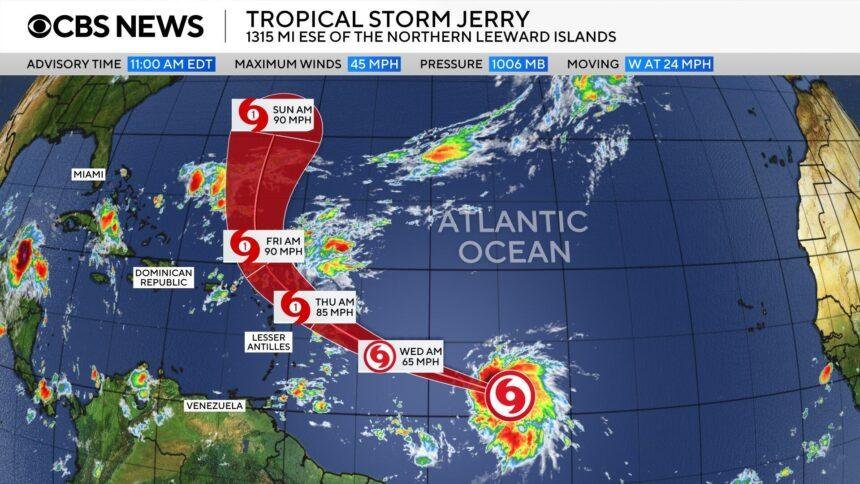
Formation and Current Status
As of Tuesday evening, Jerry was situated over 1,030 miles east-southeast of the northern Leeward Islands, a group of Caribbean islands that includes the Virgin Islands and extends down to Guadeloupe. The storm was moving west-northwest at a speed of 23 mph, with maximum sustained winds recorded at 50 mph. Forecasters predict that Jerry will continue to strengthen, potentially reaching hurricane status within the next day or so.
Impact on the Caribbean
A tropical storm watch has been issued for several Caribbean islands, including Barbuda, Anguilla, St. Kitts, Nevis, Montserrat, St. Barthelemy, Saint Martin, Sint Maarten, Saba, St. Eustatius, and Guadeloupe. Although Jerry is not currently expected to make landfall, the storm’s generated swells are likely to reach these islands by Thursday, leading to hazardous surf conditions and rip currents.
The NHC has also warned that the storm could bring up to 4 inches of rain to the Leeward Islands, raising concerns about flash flooding. The potential for heavy rainfall and dangerous surf conditions underscores the need for residents and visitors in the affected areas to remain vigilant.
Recent Storm Activity
Jerry’s formation follows a series of Atlantic storm systems, including Hurricane Humberto and Hurricane Imelda, which both developed at the end of September. While there were initial concerns that these storms could impact Bermuda, only Imelda made a close pass, reaching the island as a Category 2 hurricane before weakening as it moved into the open ocean.
Humberto and Imelda also posed threats to the southeastern United States, causing destructive surf conditions that led to the collapse of multiple coastal homes in North Carolina’s Outer Banks. These incidents highlight the ongoing risks associated with tropical storms and hurricanes, even when they do not make direct landfall.
A Quiet Hurricane Season
This year’s hurricane season has been relatively subdued compared to historical averages. While Jerry is the 10th named storm of the season, only one of the previous nine-Tropical Storm Chantal-made landfall in the United States. This contrasts sharply with the predictions made at the season’s outset by the National Oceanic and Atmospheric Administration (NOAA), which initially forecasted between 13 and 19 named storms, with up to nine expected to become hurricanes.
As the season progressed, NOAA revised its outlook in August, adjusting the forecast to predict 13 to 18 named storms, including five to nine hurricanes. This adjustment reflects the unpredictable nature of hurricane seasons, which can vary significantly from year to year.
Historical Context
Historically, the Atlantic hurricane season has seen years of both intense activity and relative calm. For instance, the 2005 hurricane season was one of the most active on record, producing 28 named storms, including Hurricane Katrina, which caused catastrophic damage in New Orleans. In contrast, the 2013 season was notably quiet, with only 13 named storms and two hurricanes.
The variability in storm activity can be attributed to a range of factors, including ocean temperatures, atmospheric conditions, and climate patterns such as El Niño and La Niña. Understanding these factors is crucial for improving forecasting models and preparing for future hurricane seasons.
Conclusion
As Tropical Storm Jerry continues to develop in the central Atlantic, residents of the Caribbean islands should remain alert and prepared for potential impacts. While the storm is not currently expected to make landfall, the risks associated with heavy rainfall and dangerous surf conditions are significant. The 2025 hurricane season has thus far been relatively quiet, but as history shows, conditions can change rapidly. Monitoring updates from the National Hurricane Center and local authorities will be essential for ensuring safety in the coming days.